Find Your Daily Voice
Tag: Winter Weather Advisory
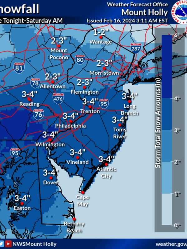
Winter Storm Warning In Effect For Lower Bucks County
Officials are advising residents across southeastern and central Pennsylvania to take caution ahead of the snowstorm predicted for Friday, Jan. 19, according to National Weather Service meteorologists.
Chester, Delaware, Philadelphia, and parts of lower Bucks and Montgomery counties are under a winter storm warning as of 5 p.m. Thursday. In Adams, Berks, Cumberland, Dauphin, Lancaster, Lebanon, Lehigh, Northampton, and upper Bucks and Montgomery counties, a winter weather advisory is in place.
NWS's Mount Holly, New Jersey station says snow will begin to fall around 4 to 7 a.m. …
First Widespread Snow Of Season Arriving In Capital Region
The region's first blast of winter arrives Tuesday night, according to forecasters.
A Winter Weather Advisory was in effect for much of the area, including Albany, Schenectady, Rensselaer, and Saratoga counties, from 10 p.m. Tuesday, Nov. 15, to 7 p.m. Wednesday, Nov. 16.
One to three inches of snow is expected for most locations, while higher elevations could see three to six inches of accumulation, according to the National Weather Service in Albany.
The storm will move across the region from the southwest to the northeast, with actual snow totals varying widely due to marginal tempera…
Storm Bringing Snow, Ice, 30 MPH Winds Takes Aim On Massachusetts
A potent, fast-moving storm will bring a mix of snow, significant icing, heavy rain, and damaging gusty winds is taking aim on the Northeast and Massachusetts.
The time frame for the storm is after nightfall Sunday, Jan. 16 into Monday afternoon, Jan. 17 on Martin Luther King Jr. Day.
A Winter Weather Advisory is in effect for Central and Western Massachusetts from midnight to 7 a.m. Monday.
After a frigid start with single-digit temperatures in the morning, Sunday's high will rebound in the afternoon and reach the low 30s, but strong winds will make it feel much cold, and clouds will…
Quick-Moving Storm System Will Bring Wintry Mix, Freezing Rain To Region
Get set for another round of wintry weather.
A Winter Weather Advisory is in effect across the interior portions of the region from 4 p.m. Monday, Dec. 27 to 7 a.m. Tuesday, Dec. 28 for most of the region, and until 10 a.m. Tuesday for northern Connecticut and Massachusetts.
A light wintry mix could leave a glaze of ice in these areas, according to the National Weather Service.
For New York City, Long Island, and coastal Westchester and Connecticut, where the advisory is not in effect, spotty light snow or sleet will become plain rain in the evening, the weather service said.
There will b…