Find Your Daily Voice
Tags
Follow
News
Schools
Business
Obituaries
Police & Fire
Weather
Neighbors
Lifestyle
Politics
Sports
Events
Traffic
Legal
Real Estate
Tags
Jobs
Shop
Support Us
Follow
Find Your Daily Voice
News
Schools
Business
Obituaries
Police & Fire
Weather
Neighbors
Lifestyle
Politics
Sports
Events
Traffic
Legal
Real Estate
Tags
Jobs
Shop
Support Us
Home
About us
All sites
Advertise with us
Contact us
Terms of use
Privacy policy
Code of ethics
Site Map
© 2024 Cantata Media
Tag:
Winter Storm
White Plains
Weather
How Much Snow Did You Get? New Winter Storm Produces Higher-Than-Expected Totals In These Areas
A quick-moving winter storm that is now moving east produced higher-than-expected snowfall totals in some parts of the region, especially in and around New York City and on Long Island. Totals are from the National Weather Service and submissions from Daily Voice readers: Location Amount Time/Date Provider New York New York City New York County (Manhattan) Central Park 2.0 inches 0700 AM 02/17 Official NWS Obs SE Greenwich Village 3.2 inches 0920 AM 02/17 NWS Employee Kings County (Brooklyn) Coney Island 9.9 inches 0655 AM 02/17 Trained Spotter Coney Is…
White Plains
Weather
New Update: How Much Snow Did You Get? Reports From Westchester, Region For Winter Storm
Here are snowfall reports from the region for the winter storm that is sweeping through the Northeast on Tuesday, Feb. 13. Totals are from the National Weather Service and submissions from Daily Voice readers: Location Amount Time/Date Provider New York Westchester County Peekskill 10.3 inches 1000 AM 02/13 Public Croton-on-Hudso 10.5 inches 12:45 PM 02/13 Daily Voice reader submission North Salem/Peach Lake 10.0 inches 0430 PM 02/13 Daily Voice reader submission Croton-on-Hudson …
Monmouth
Weather
Winter Storm Knocks Power To Thousands Of Jersey Shore Residents
A pre-Valentine's Day winter storm knocked out power for thousands of Jersey Shore customers. According to the outage map for Jersey Central Power & Light (JCP&L), 4,019 customers in Monmouth County lost electricity as of 11:45 a.m. on Tuesday, Feb. 13. The vast majority of those were in Ocean Township with 3,371 customers without power, which is nearly 25 percent of the township. At least 100 customers were without service in Middletown, Tinton Falls, Colts Neck, and Manalapan. JCP&L also said 24 customers lost power in Ocean County. Sixteen of those were in Toms River. …
Worcester
Weather
Lower Updated Snow Totals For Mass; Gov. Healey Says Residents Should Prepare Emergency Kits
The National Weather Service said the winter storm expected to batter much of the Northeast on Tuesday, Feb. 13, has taken a "southward shift," which could mean less snow for Massachusetts. Gov. Maura Healey has asked residents to prepare and take precautions anyway. According to the latest prediction models, the northwestern portion of the state is now expected to receive to up 3 inches of snow, with a band running from the west through Springfield and up to Lawrence getting as much as 6 inches, according to forecasters. Worcester and Boston could receive 6 to 8 inches. …
Union
Schools
North Jersey Schools Closed, Delayed Due To Major Winter Storm
New Jersey school districts are announcing closures and delays ahead of a winter storm expected Monday night into Tuesday, Feb. 13. Between 6 and 18 inches are expected across North Jersey, but the National Weather Service "the Tuesday morning commute will be either snowy, slushy, or wet for our entire area." The following districts have announced closures Tuesday, Feb. 13: Belleville Bergenfield Bloomfield Butler Clifton Closter Cresskill Demarest Denville Dover Dumont Englewood Englewood Cliffs Elizabeth Elmwood Park Fair Lawn Fort Lee Franklin Lakes Fredon Garfield Glen Rock Hack…
Sussex
Weather
Murphy Urges NJ Residents Work From Home, Stay Off Roads Ahead Of Winter Storm
New Jersey Gov. Phil Murphy is urging residents to stay off the roads ahead of a winter storm expected Monday, Feb. 12 into Tuesday, Feb. 13. The National Weather Service was predicting up to 18 inches of snow in the northernmost part of the state, with between 6 inches and a foot possible across Sussex, Warren, Morris, Hunterdon, Somerset, Passaic, Bergen, and western Essex counties, where a Winter Storm Warning was issued. Murphy said the most intense stretch of precipitation, beginning as rain and turning to snow, will happen in the middle of the night and run into mid-morning…
Atlantic
Weather
Here's Where To Find Free Parking During Winter Storm In Atlantic City
An Atlantic City casino parking garage is allowing people to protect their cars during a pre-Valentine's Day winter storm. Free parking will be allowed for Atlantic City residents and visitors at the Wave Parking Garage, the New Jersey Casino Reinvestment Development Authority (CRDA) announced. The garage is at the corner of Mississippi and Fairmount avenues. Free parking started at 4 p.m. on Monday, Feb. 12 and it will continue until 8 a.m. on Wednesday, Feb. 14. Parking will only be allowed on the second floor. CRDA offers free parking at Wave Garage for Atlantic City residents …
Howard
Weather
Rain May Turn To Snow In Parts Of DMV Region During Shifty Incoming Storm: Forecasters
Some parts of the DMV region could be hit with snow as another round of storms is expected to roll through the area. Forecasters are advising that some parts of the area could see winter weather, specifically in the mountains, though many other neighborhoods will only see rain falling beginning late on Monday and into Tuesday morning. We have some winter weather on the way for Maryland including potential snow fall tonight into tomorrow. Keep an eye on @NWS_BaltWash, your local forecasts, and here for continued updates. #MdWx https://t.co/3jWmTmz5Uo — Maryland Department of Emergen…
Atlantic
Weather
Coastal Flooding, Wind Expected From Pre-Valentine's Day Winter Storm On Jersey Shore
While many parts of the Jersey Shore won't see snow, a winter storm is expected to bring some issues right before Valentine's Day, forecasters said. According to the National Weather Service, moderate coastal flooding is forecasted from Perth Amboy to Cape May on Tuesday, Feb. 13. Minor flooding coastal flooding is expected along the Delaware Bay and Delaware River. Parts of Burlington, Cumberland, Monmouth, Ocean, and Salem counties are expected to get about an inch of snow. While inland Atlantic County could see some snow, the coast and Cape May County aren't forecasted to receive any acc…
Union
Weather
Increased Snow Projections: 18 Inches Could Fall In Parts Of NJ, PA In Major Storm, NWS Says
The National Weather Service says parts of New Jersey and Pennsylvania could see more snow than what was initially predicted due to a shift in the storm track. In an updating briefing published Monday, Feb. 12, the NWS said 12 to 18 inches of snow could fall in parts of Sussex County, NJ and the Pocono Mountains. ALSO SEE: North Jersey School Closed, Delayed Ahead Of Major Winter Storm The weather map shows between 8 and 12 inches expected in parts of Bergen, Morris, Passaic, Essex, Warren, Somerset and Hunterdon counties, where winter storm warnings have been issued. Winter weather a…
Washington
Weather
New Weather Map Shows Snow Potential In Pre-Valentine's Day Storm Nearing Northeast
AccuWeather has released a new weather map ahead of a winter storm approaching the Northeast. The above model shows rain and/or snow taking aim at most of Pennsylvania, New Jersey, and northern Maryland early next week, likely sometime Monday, Feb. 12 into Tuesday, Feb. 13. "While the January thaw and break from the stormy pattern extended into early February, there is going to be a change in the pattern with a potentially impactful storm coming swinging across the Midwest and Northeastern states from Monday to Tuesday," AccuWeather Meteorologist Dean DeVore said. Precipitation is expected…
Nassau
Weather
'Dust Off Your Snow Shovels': Here's Latest On Pre-Valentine's Day Storm Taking Aim At Region
An upcoming stretch of unseasonably warm temperatures will be followed by the potential for a pre-Valentine's Day winter storm early next week. Click here for a new, updated story - First Snowfall Projections Released For Pre-Valentine's Day Winter Storm "It may be time to dust off your snow shovels as a flip in the weather pattern could send a snowstorm over parts of the Midwest and Northeast just days after a spell of unusual warmth," according to AccuWeather.com. The system could start a "back to reality" shift to a weather pattern more typical of February. "While the Janua…
Putnam
Police & Fire
Driver Emerges Unharmed After Rollover On Snowy Mahopac Road
Despite flipping their car onto its side on a busy Hudson Valley road amid snowy conditions, a driver was able to walk away from the crash unharmed, fire officials said. The crash happened in Putnam County on Tuesday, Jan. 16 just before 8 a.m., when a car rolled over and landed on its side on Croton Falls Road (Route 34) in the area of McLaughlin Drive, according to the Mahopac Volunteer Fire Department. Miraculously, the driver was not injured and was able to get themselves out of the vehicle before first responders arrived, the fire department said. The crash happened d…
New Haven
Weather
How Much Snow Did You Get? Here Are Reports From Region For Winter Storm
Here are snowfall reports from the region for the winter storm that swept through the Northeast overnight Monday, Jan. 15 into Tuesday, Jan. 16. Totals are from the National Weather Service: Location Amount Time/Date Provider New York Westchester County New Rochelle 1.7 inches 0730 AM 01/16 Public Peekskill 1.3 inches 0630 AM 01/16 Public Armonk 1.3 inches 0800 AM 01/16 COCORAHS Peekskill 2.8 NNE 1.0 inches 0800 AM 01/16 COCORAHS South Salem 0.8 inches 0715 AM 01/16 COCORAHS Nassau County Levittown 3.0 inches…
Arlington
Weather
Possibility Of Snow, Ice Storm For Northeast Next Week Hinges On One Factor: AccuWeather
A winter storm could hit the Northeast next week, but it depends on one factor, forecasters say. A dip in the jet stream. “Should a large dip develop in the jet stream, then a major winter storm will climb the Atlantic coast from Monday night to Tuesday night,” AccuWeather Senior Meteorologist Bob Smerbeck explained. “However, should only a shallow dip in the jet stream develop, the storm would be more likely to escape out to sea, off the southern Atlantic coast by midweek.” Weather maps show a dusting of between one and three inches, should the snow make its way up to New Jersey, eastern…
New Haven
Police & Fire
Trooper Hospitalized After Car Slams Into Cruiser On I-91 In Meriden During Storm: Police
A state trooper was taken to a hospital after a car driven by a 20-year-old New York resident crashed into the back of her cruiser on a Connecticut highway amid a winter storm, police announced. The incident happened in New Haven County during a winter storm on Tuesday, Jan. 9 around 7:40 p.m., when a state police cruiser was parked in the left lane of Interstate 91 South in Meriden while helping with a call for traffic service. According to state police, a 2016 Cadillac Escalade driven by Putnam County resident Luis Sanchez, Jr. of Brewster, age 20, was traveling south in the left la…
Frederick
Weather
New Snowfall Predictions Released For Mid-Atlantic, Worst Of Storm Yet To Come: Weather Service
The highly-anticipated weekend storm is under way in the mid-Atlantic. But according to the National Weather Service, the worst is yet to come. A winter storm warning remains in effect until 7 p.m. from the Baltimore/Washington DC National Weather Service, who warned of slippery and dangerous road conditions through the evening. Sleet and freezing rain were arrived in northern Virginia and Maryland Saturday morning, Jan. 6, and was expected to remain light until the afternoon and evening, the NWS said. In northern Maryland, between 2 and 4 inches of snow accumulation was expected by the e…
York
Weather
NWS: Winter Storm Warnings Issued In The Following Pennsylvania Counties
Almost half of Pennsylvania's counties are under winter storm watches, warnings, and advisories issued by the National Weather Service. From Saturday until Sunday, the following Pennsylvania counties are being alerted by the NWS for a heavy winter storm: Adams. Allegheny. Bedford. Blair. Cambria. Cameron. Carbon. Centre. Columbia. Clearfield. Clinton. Cumberland. Dauphin. Fayette. Franklin. Fulton. Huntingdon. Indiana. Juniata. Lackawanna. Lebanon. Luzerne. Lycoming. Mifflin. Monroe. Montour. Northumberland. Perry. Pike. Schuylkill. Snyder. Somerset. Sullivan. Susquehanna. Union. Wayne. Wy…
Worcester
Weather
Updated Snow Predictions Show How Much Snow Coming In Central Mass This Weekend
The National Weather Service says Bay Staters should prepare to be blanketed by snow this weekend. As much as a foot is forecast to fall for most of Massachusetts on Sunday, Jan. 7. On Thursday, the National Weather Service in Boston said a cold front moving into the region Thursday night and Friday is setting the stage for high winds and cold temperatures north of I-95. That precipitation will likely come in the form of snow — a lot of it. A winter storm watch is in effect from Saturday evening through Sunday night. Heavy snow accumulations of 8-12 inches is possible north a…
White Plains
News
Winter Storm - Hochul Warns NYers To Prepare For Snow, Possible Power Outages: 'Be Vigilant'
As a powerful Nor'easter threatens to dump inches of snow and a wintry mix on much of New York State, Gov. Kathy Hochul is urging residents to prepare for power outages and travel hazards posed by the white stuff. According to Hochul, the large coastal weather system is predicted to hit New York late Saturday, Jan. 6, and continue into Sunday, Jan. 7, bringing anywhere from 3 to 12 inches of snow to parts of the Hudson Valley, Capital Region, and Central New York, and a mix of snow and rain to New York City and Long Island. Winter storm watches are in effect throughout New York S…
Arlington
Weather
Wintry Mix Of Rain, Possible Snow Expected In DMV Region Over Weekend
Forecasters are expecting a wet, wintry weekend throughout the region as storms make their way toward the DMV region. During the first weekend of 2024, there will be "an enhanced winter storm threat" for portions of region beginning on Saturday and extending through the evening, according to the National Weather Service There is an enhanced winter storm threat for portions of our region Saturday into Saturday night. The highest confidence for impacts of snow & ice appear to be along & west of the Blue Ridge. This forecast will continue to change. Latest at : https://t.co/ZOlvEShg…
Nassau
Weather
First Projected Snowfall Totals Released For Major Storm Headed To Northeast
The first projected snowfall totals have been released for a potent coast-to-coast winter storm expected to hit the Northeast midway through the weekend. Click here for a new, updated story - Projected Snowfall Totals Increase As Nor'easter Nears: These Spots Could See 18 Inches Snowfall is expected to begin overnight Saturday, Jan. 6 into Sunday, Jan. 7, according to the National Weather Service. Areas in the darker shade in the image above from AccuWeather.com are expected to see between 6 and 12 inches of snowfall, including parts of upstate New York, northern Connecticut and areas…
Warren Hunterdon
News
Lights Out! 700 Without Power In Hunterdon County
Nearly 700 Hunterdon County JCP&L customers were without power Tuesday afternoon, March 14 as a winter storm swept through the area. Wind gusts of up to 50 mph were expected through Wednesday, March 15, according to the National Weather Service. Gusty winds across the region March 13-15.AccuWeather According to JCP&L, the majority of the outages were in Lebanon Township (227); 135 were in Califon; 148 were in Delaware; and various other towns had between 30 and 50 outages. Restoration time varied between 3 and 5 p.m.
Worcester
Weather
School Closings: Worcester Districts Join Growing List As Winter Storm Looms
The National Weather Service has issued a hazardous weather outlook for Central and Western Massachusetts on Monday, March 15, through Wednesday as a nor'easter will blanket the area with heavy snows and high winds. Several schools have announced they will be closed on Tuesday. The Berkshires Adams-Cheshire Regional School District Berkshire Hills Regional School District Central Berkshire Regional School District Farmington River Regional School District Gabriel Abbott Memorial School Hancock Regional School District Lee Public Schools Mount Greylock Regional School District North Ad…
Southwest Dutchess
Weather
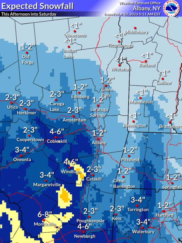
Projected Snowfall Totals Increase For Winter Storm Headed To Region
Projected snowfall totals have increased for a new winter storm headed to the region. The time frame for the system is Friday night, March 10 into Saturday, March 11, according to the National Weather Service. A widespread 4 inches of accumulation is now predicted for most inland areas south of the Capital Region, with close to 6 inches in some spots, where hazardous travel is expected. (See the images above from the National Weather Service.) In New York, less snow, generally 1 to 2 inches, is expected in the Albany area and farther north. In Connecticut, less snow is predicted for centr…
White Plains
Weather
Projected Snowfall Totals Increase For Winter Storm Headed To Region
Projected snowfall totals have increased for a new winter storm headed to the region. The time frame for the system is Friday night, March 10 into Saturday, March 11, according to the National Weather Service. A widespread 4 inches of accumulation is now predicted for most inland areas, with close to 6 inches in some spots, where hazardous travel is expected. (See the image above from the National Weather Service.) For New York City, Long Island, and coastal areas, a wintry mix is expected from the storm, but accumulations of 1 to 2 inches are possible. Clouds will increase on Friday with…
New Haven
Weather
New Snowfall Projections Released For Winter Storm Headed To Region
Click here for a new, updated story: Projected Snowfall Totals Increase For Winter Storm Headed To Region New snowfall projections have been released for a new winter storm headed to the region. The time frame for the system is Friday night, March 10 into Saturday, March 11, according to the National Weather Service. Much of the region is expected to see 1 to 3 inches of snowfall (shown in light blue in the image above from AccuWeather.com). Areas farther west could see 3 to 6 inches (Columbia blue) and 6 to 12 inches (blue). For New York City, Long Island, and coastal areas, a wint…
New Haven
Weather
Projected Snowfall Totals Released For New Winter Storm Taking Aim On Northeast
Updated story: New Snowfall Projections Released For New Winter Storm Taking Aim On Northeast Projected snowfall totals have been released for a new storm on track for the Northeast later this week. The time frame for the system is Friday night, March 10 into Saturday, March 11, according to the National Weather Service. Much of the region is expected to see 1 to 3 inches of snowfall (shown in light blue in the image above from AccuWeather.com). Areas farther west could see 3 to 6 inches (Columbia blue) and 6 to 12 inches (blue). Areas farther east, including Long Island, Connecticu…
New Haven
Weather
Approaching Winter Storm Could Bring Snowfall To Northeast: Here's Projected Timing
New update: Projected Snowfall Totals Released For New Winter Storm Taking Aim On Northeast A brand-new storm on track for this week could bring accumulating snowfall to the Northeast. The time frame for the system is Friday night, March 10 into Saturday, March 11, according to the National Weather Service. "It is possible for accumulating snow to reach all the way to coastal areas of New Jersey, New York, and southern New England," AccuWeather Meteorologist Joseph Bauer said. Ahead of the expected arrival of the storm, the remainder of the workweek will be dry and breezy, the Nation…
Litchfield
Weather
Quick-Moving New Winter Storm Will Bring Snow, Sleet, Rain To These Parts Of Region
Parts of the region are expected to see a mix of snow, sleet, and rain from a quick-moving winter storm overnight. The time frame for the system is late Monday night, March 6 into early Tuesday morning, March 7, according to the National Weather Service. The current projected track for the system has been trending south, with New York City and parts of Long Island now expected to see some snowfall, according to the National Weather Service. (See the first image above.) "Snow amounts should stay under 0.5 inches, but local higher amounts of about an inch are possible," the weather service s…
Stamford
Weather
Storm Scenarios: Final Track Will Determine What Parts Of Region Could See Wintry Mix
A new winter storm could bring a mix of snow, sleet, and rain that could cause slippery travel conditions in parts of the region. The time frame for the system is late Monday night, March 6 into Tuesday morning, March 7, according to the National Weather Service. But its projected track is uncertain. One forecast model is taking it a bit farther west. (See the image above from AccuWeather.com.) In those inland areas, 1 to 3 inches of snowfall is possible. Areas farther west could see 3 to 6 inches of accumulation. Another model has the system moving more to the east, meaning m…
1
2
3
4
5
6
7
8
9
10
Archive