Find Your Daily Voice
Chance Of Snow For NJ, PA In Sunday Soaker: Forecasters
Temperatures are expected to surge near 60 by the end of the week, but come next, parts of New Jersey and Pennsylvania could be back in old man winter's grip, forecasters say.
According to AccuWeather, a storm on Sunday, Jan. 29 will bring rain to major cities.
For northwest New Jersey, northern Pennsylvania and parts of Central Pennsylvania, however, a mix of rain and snow — or perhaps just snow — is expected.
Thursday, Jan. 25 will be rainy and foggy with a high near 50 while Friday, Jan. 26 will be the same but slightly cooler, the NWS said. Saturday will be partly sunny with a hi…
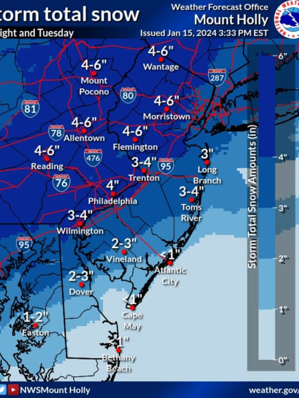
Six Inches Of Snow Could Slam Parts Of NJ, PA: Latest Forecast, Timing Updates
Newly-released forecast maps from the National Weather Service show up to six inches of snow could fall across eastern Pennsylvania and much of New Jersey.
Accumulating snowfall will begin Monday, night Jan. 15, mainly after 7 p.m., and carry into Tuesday morning, Jan. 16, impacting the morning commute as it changes over to a wintry mix, the NWS said in its latest briefing.
ALSO SEE: North Jersey School Delays For Tuesday, Jan. 16
Between 4 and 6 inches of snow was being forecast for most of North Jersey (including Morris, Sussex, pars of Bergen/Essex/Hudson, Warren, and Hunterdon Counties…
Sunday Snow Squalls Possible In Parts Of DMV Region, Forecasters Caution
Another storm may bring upwards of an inch of snow to parts of Maryland, Virginia, and DC on Sunday, according to forecasters.
While the DMV region won't face the same perils that forced the NFL to postpone the Buffalo Bills playoff game in upstate New York, some parts of the area may see a wintry mix on Jan. 14 as they celebrate the holiday weekend.
Temperatures began cooling down on Saturday, with a cold front heading in that could bring whipping winds, some snow showers, and other inclement weather, officials say.
Behind a cold front, temperatures will cool off through the day. This …
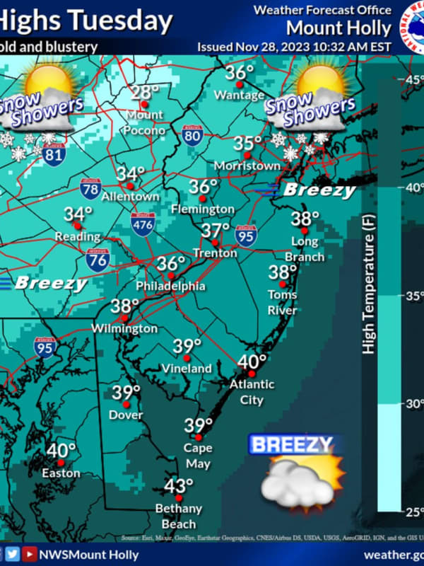
Snow Flurries Possible This Evening In Parts Of North Jersey
Wintry weather may be working its way through parts of North Jersey later today, Tuesday, Nov. 28.
The National Weather Service was predicting up to a 40 percent chance of flurries in the northern and westernmost parts of the state in the late afternoon and evening hours.
Bergen, Passaic, Essex, Morris, Union, Sussex, Warren, and Hunterdon counties could all see snow through the evening, according to the NWS.
The greatest chance of snow is in Sussex County, where the NWS predicted a 40% chance of flurries before 5 p.m.
🥶🧥 Temperatures will remain steady in the 30s for the remainder o…
'Temperature Turnaround:' Unseasonably Warm Weather Coming To Northeast
Mother Nature isn't ready for winter yet — or fall, for that matter.
While this week got off to a chilly start in the Northeast, the finish will be anything but, forecaster say.
Tuesday, Oct. 24, and Wednesday, Oct. 25 will be sunny with temps in the high 60s, Thursday, Friday, and Saturday will reach highs around 75.
In Philadelphia, Washington DC, and Baltimore, temperatures could climb as high as 80, AccuWeather says, calling it a "temperature turnaround."
The forecast low tonight in Philly is 40°. The last time the low was 40° or less in Philly this year was April 10, when... Pos…
Possible Showers, Thunderstorms To Close Out Sunny Week In Virginia: Forecasters
A picture-perfect day will be followed by several more with looming thunderstorms in northern Virginia and Washington DC, forecasters say.
Wednesday, Aug. 23 will be sunny with low humidity and a high near 83, and increasing clouds in the afternoon, the National Weather Service says.
Thursday, Aug. 24 will be filled with scattered showers and a chance of thunderstorms, according to the NWS.
Friday, Aug. 25 will be partly sunny with a high near 91, and a chance of showers and more thunderstorms. Saturday will also be sunny with a high near 87, and with a chance of thunderstorms, the N…