Find Your Daily Voice
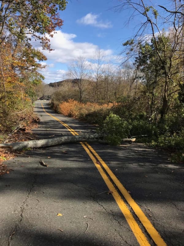
Long-Duration Storm: Be Ready For Wintry Mix, Power Outages, Flooding, Hochul Warns NYers
Ahead of an upcoming storm system expected to last several nights, New York Gov. Kathy Hochul is urging residents across the state to prepare for snow, heavy rains, power outages, and flooding.
According to the latest predictions, the storm is expected to arrive in the Hudson Valley, Capital Region, and Long Island on Tuesday, April 2, and continue through Thursday night, April 4, bringing poor travel conditions and likely power outages along with it, Hochul announced.
Related Report - Strengthening Nor'easter Will Bring Heavy Rain, Gusty Winds, Up To 2 Feet Of Snow In Spo…
How Much Snow Did You Get? A Look At Totals From Throughout Region
The most potent winter storm of the season has resulted in scores of school closures and slippery travel conditions.
Here's a look at some snowfall totals reported to the National Weather Service and other sources on Tuesday morning, Feb. 28.
If you don't see your town listed, post the total in a comment.
New York
Manhattan
Central Park, 1.8 inches
Nassau County
Manhasset Hills, 3.5 inches
Herricks, 3.5 inches
Suffolk County
Commack, 5 inches
Centereach, 4.5 inches
Mattituck, 4.5 inches
Mount Sina, 4.5 inches
Bridgehampton, 4.4 inches
Rockland County
Stony Point, 6.1 inc…
Icy Mix Of Freezing Rain, Sleet, Snow Causes Hazardous Travel, Many School Closures
The arrival of a massive winter storm bringing a mix of snow, sleet and freezing rain has caused hazardous travel conditions and many school closures throughout the region on Friday, Feb. 25.
The wide area where icy conditions are causing slippery travel conditions are shown in the first image above.
A look at the types of precipitation by area on Friday, Feb. 25 are shown in the second image above: Rain/snow/ice (in pink), snow (blue), and rain/showers (green).
Click on the second image above for a look at the types of precipitation the storm will bring, with rain in green, rain/snow…
Icy Mix: Storm Bringing Freezing Rain, Sleet Could Cause Hazardous Travel Conditions
A new storm sweep that will sweep through the region won't bring more snowfall but will be accompanied by freezing rain and sleet that could lead to dangerous travel conditions.
The time frame for the storm is Sunday, Jan. 9, from about daybreak to 11 a.m.
Total ice accumulations of a light glaze is possible, the National Weather Service said in a Hazardous Weather Outlook statement issued Saturday morning, Jan. 8.
For a look at areas most at risk for seeing freezing rain, sleet, and hazardous driving conditions, see the first image above. .Very slippery sidewalks, roads, and bri…
Blizzard: Foot Of Snow Possible Across South Jersey
Up to a foot of snow was possible Monday in South Jersey, with blizzard conditions likely to last until the afternoon.
Only a light dusting to an inch was expected in the northern part of the state.
A State of Emergency was declared in Atlantic, Burlington, Cape May, Cumberland and Ocean counties by Gov. Phil Murphy Sunday night.
Meanwhile, the National Weather Service expanded a winter storm warning to Atlantic, southeast Burlington, Camden, Cape May, Cumberland, Gloucester, Ocean and Salem counties until 4 p.m., according to the National Weather Service.
Snowfall rates around…
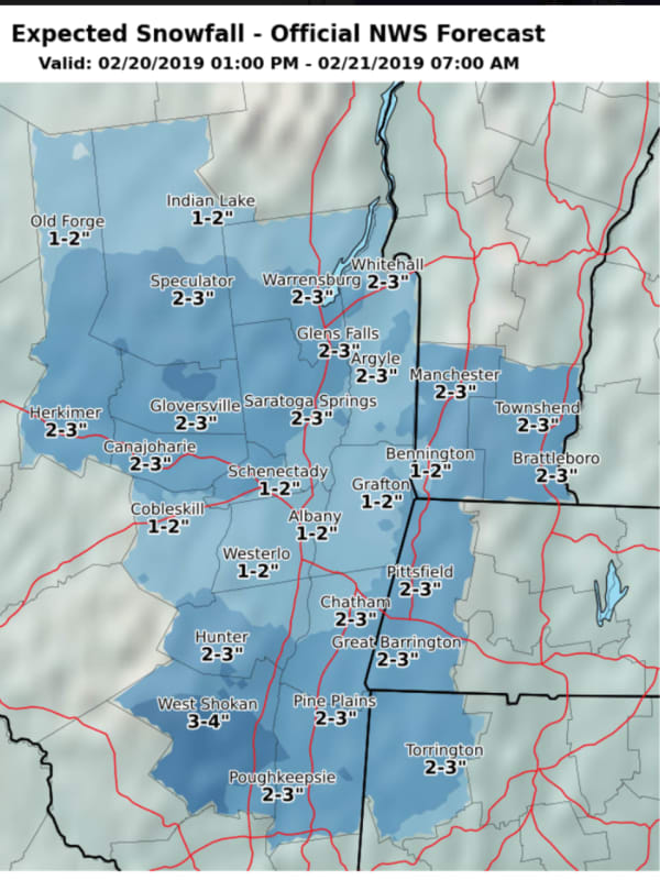
Endless Winter's Not Over Yet: Here's What To Expect From Next Storm System
It's been an endless winter, and it's not over yet.
For starters, the slow-moving late-week storm system that arrived on Thursday, Feb. 18 delivered a parting shot to parts of the region with a surprising new round of light snow on Saturday morning, Feb. 20, causing slippery travel conditions.
Skies will clear though, leading to a mostly sunny day on Saturday, Feb. 20 with a high temperature in the low 30s, and wind-chill values in the teens.
It will remain clear and cold overnight and on Sunday, Feb. 21, which will also be sunny with a high temperature in the low 30s and wind-chill values…
Storm Watch: System Will Bring Snow, Sleet Inland, With All Rain Farther South
A complex storm system will create hazardous travel conditions for much of upstate New York and Connecticut with a combination of sleet and snow leading to ice-storm conditions with power outages possible.
Farther south, including New York City, Long Island, as well as Westchester, Putnam, Rockland, Orange and Fairfield counties, precipitation will be all rain as the low temperature will stay above freezing.
Winter Weather Advisories are in effect from 5 p.m. Sunday, Dec. 29 through 7 a.m. Tuesday, Dec. 31 for the counties shown in purple in the first image above, including Dutchess an…
How Much Snow Did You Get? A Look At Totals From The Region
The slow-moving, two-part Nor'east has now moved out off the coast, but it resulted in difficult travel conditions, school delays and closing and scattered power outages.
Here are some selected snowfall totals from the region. Add the total for your town by leaving a comment below.
Fairfield County
Bridgeport, 2 inches, 12 a.m. Tuesday, Dec. 3
New Fairfield, 6.7 inches, 4 a.m. Tuesday, Dec. 3
Ridgefield, 3 inches, 6 a.m. Tuesday, Dec. 3
by
Daily Voice