Find Your Daily Voice
5 Displaced After Home Struck By Lightning In Montgomery County (Photos)
A house in Montgomery County was struck by lightning during a thunderstorm on Thursday evening, Feb. 22, authorities said.
The two-story house at 21600 Gentry Ln. near Cross Meadow Lane was struck by lightning accompanied by “extreme thunder” around 5:45 p.m., Montgomery County (MD) Fire & Rescue Service Chief Spokesperson Pete Piringer said.
No fire or injuries were reported, though the home did sustain other structural damages, displacing five residents, Piringer added.
Scroll down to view additional photos.
21,600 Gentry Ln. near Cross Meadow Ln., Brookville, 2-sty house, house …
Tornado Touchdown Confirmed In Permberton
Two small tornados touched down in New Jersey and Pennsylvania amid thunderstorms Friday, June 16, the National Weather Service confirmed,
The both were EF-0 twisters: One in Pemberton (Burlington County, NJ), and the other in West Caln Township (Chester County, PA).
The Pemberton tornado's trail began in Southampton Township near Burrs Mill Road south, uprooting six trees as it traveld 3.4 miles to Ongs Hat Road, Stockton Bridge Road, and across Magnolia Road, at 12:55 p.m. in Pemberton, the NWS said.
Confirmed tornado in Pemberton Township Burlington County, NJ. The image shows the p…
Hudson Valley Village Devastated By Severe Storm With 60 MPH Winds Causing Many Power Outages
A severe thunderstorm caused heavy damage to a Hudson Valley village as whipping winds sent trees flying, downed utility lines, and left thousands without power.
On Wednesday, June 30, at approximately 7 p.m., the powerful storm tore through Dutchess County, with Wappingers Falls among the hardest-hit areas, with thousands reporting outages as utility poles and lines were toppled.
According to the National Weather Service, wind gusts approached 60 mph, with more than 4,000 losing power at the peak of the storm. Hundreds were still awaiting the restoration of power in the area on Thursday m…
Severe Thunderstorm Watch In Effect For Most Of Region
A Severe Thunderstorm Watch is now in effect for much of the region.
It lasts until 10 p.m. Wednesday, June 30, and covers Westchester, Rockland, Putnam, Dutchess, Orange, Ulster, Sullivan, Greene, Columbia counties in New York, Fairfield, Hartford, Litchfield, New Haven, Tolland, New London, and Middlesex counties in Connecticut, and all of Massachusetts except Cape Cod, and northeast Pennsylvania. (See image above.)
Torrential rainfall is likely during storm activity. Quarter-sized hail, damaging winds, and frequent lightning are possible, along with power outages, the National …
Severe Thunderstorm Watch In Effect For Parts Of Region With Strong Winds, Tornadoes Possible
A Severe Thunderstorm Watch has now been issued for parts of the region.
It lasts until 11 p.m. Monday, June 21, and covers Dutchess, Ulster, Sullivan, Greene, Albany, Columbia, Delaware, Otsego, Rensselaer, and Schenectady counties in New York, Litchfield County in Connecticut, and Berkshire County in Massachusetts.
Torrential rainfall is possible during storm activity. Large hail of 1 inch in diameter or greater, damaging winds, and an isolated tornado or two are the main threats, said the National Weather Service, which issued the watch.
More storms are expected again on Tuesd…
Strong To Severe Storms Will Bring Damaging Wind Gusts, Possible Tornadoes, Hail
A line of thunderstorms will sweep through the region, bringing the potential for severe weather.
The time frame for the storm system, which will be ignited by an approaching cold front, is late Wednesday afternoon, May 26 through Wednesday evening.
Damaging wind gusts, large hail, and a couple of tornadoes are possible, the National Weather Service said in a Hazardous Weather Outlook statement issued Wednesday.
"Strong to damaging wind gusts will be the main threat," the statement said.
The high temperature will shoot back up to the upper 80s to around the 90-deg…
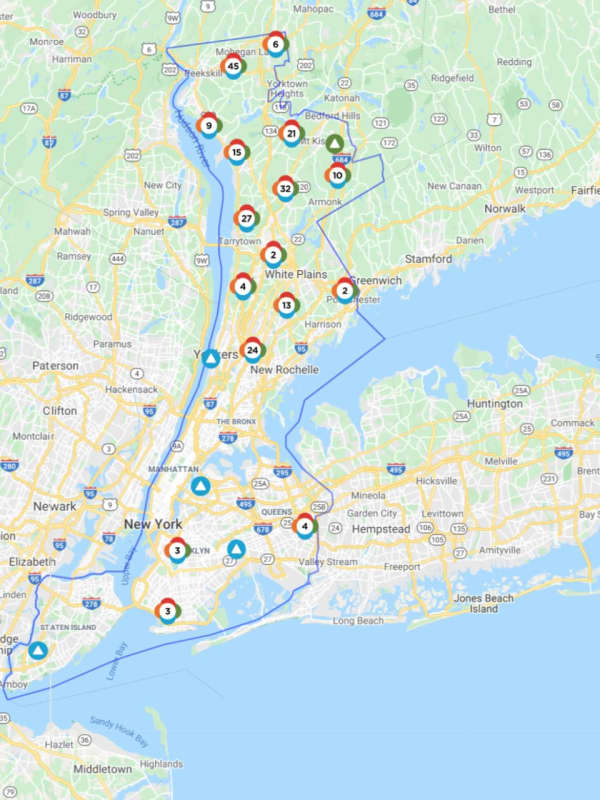
Here's How Many Are Still Without Power After Damaging Storm Slams Westchester
Thousands of Westchester residents remain without power a day after thunderstorms struck the region, taking down tree limbs and power lines.
As of 9:45 a.m. on Tuesday, April 14, Con Edison was reporting that 3,637 of its 348,198 Westchester residents were still without power. Additionally, 3,969 of NYSEG’s Northern Westchester customers were still in the dark.
The hardest-hit municipalities were in Northern Westchester, with Yorktown reporting 1,954 outages, followed by Bedford (1,022 outages), Somers (685), Cortlandt (651), New Castle (413), Briarcliff Manor (412), and Ossining (401).
…