Find Your Daily Voice
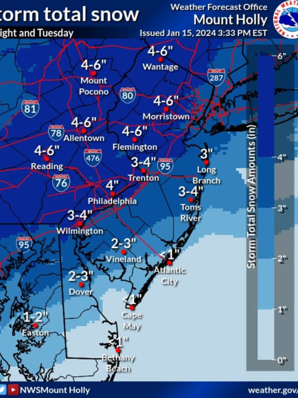
Six Inches Of Snow Could Slam Parts Of NJ, PA: Latest Forecast, Timing Updates
Newly-released forecast maps from the National Weather Service show up to six inches of snow could fall across eastern Pennsylvania and much of New Jersey.
Accumulating snowfall will begin Monday, night Jan. 15, mainly after 7 p.m., and carry into Tuesday morning, Jan. 16, impacting the morning commute as it changes over to a wintry mix, the NWS said in its latest briefing.
ALSO SEE: North Jersey School Delays For Tuesday, Jan. 16
Between 4 and 6 inches of snow was being forecast for most of North Jersey (including Morris, Sussex, pars of Bergen/Essex/Hudson, Warren, and Hunterdon Counties…
Icy Mix: Storm Bringing Freezing Rain, Sleet Could Cause Hazardous Travel Conditions
A new storm sweep that will sweep through the region won't bring more snowfall but will be accompanied by freezing rain and sleet that could lead to dangerous travel conditions.
The time frame for the storm is Sunday, Jan. 9, from about daybreak to 11 a.m.
Total ice accumulations of a light glaze is possible, the National Weather Service said in a Hazardous Weather Outlook statement issued Saturday morning, Jan. 8.
For a look at areas most at risk for seeing freezing rain, sleet, and hazardous driving conditions, see the first image above. .Very slippery sidewalks, roads, and bri…