Tag:

Arctic

Manassas Army Flight Medic Wins National Award For Sky-High Saves Manassas Army Flight Medic Wins National Award For Sky-High Saves
Manassas Army Flight Medic Wins National Award For Sky-High Saves A U.S. Army flight medic from Virginia is among a handful of responders being recognized nationally. The National Association of Emergency Medical Technicians has awarded SSG Sean Clerkin, of Manassas, with the American Rescue Military Medic of the Year Award. Here's why. "Clerkin sets himself apart as a special operations medic, flight medic, and leader," the NAEMT description says. "He has an incredible work ethic, exemplifies servant leadership and demonstrates passion for educating others and pursuing medical knowledge." In addition to his significant contributions to t…
Blast Of Arctic Air Headed To Northeast, Forecasters Say Blast Of Arctic Air Headed To Northeast, Forecasters Say
Blast Of Arctic Air Headed To Northeast, Forecasters Say 
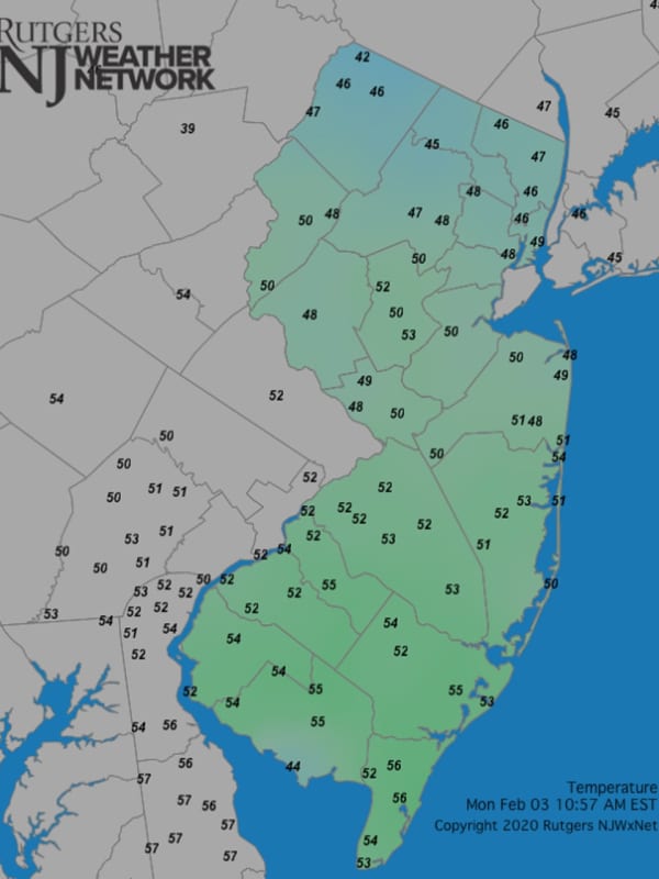
A mild January has paved the way for a cold start to February. A "quick but intense" burst of Arctic air is headed to the Northeast, meteorologists at AccuWeather.com say. Forecast Saturday, Feb. 5.AccuWeather The week is starting out with temps in the high 40s or even low 50s, but by Saturday, Feb. 5, temps could be as low as 23, according to the National Weather Service. In the mid-Atlantic, temps will "struggle to reach the 32-degree mark" on Saturday, AccuWeather.com says. Until then, the week will be mostly sunny with temps gradually dropping each day, meteorologists say. [T…
White Christmas? New Storm Could Bring Potentially Significant Snowfall To Much Of Region White Christmas? New Storm Could Bring Potentially Significant Snowfall To Much Of Region
White Christmas? New Storm Could Bring Potentially Significant Snowfall To Much Of Region Dreaming of a White Christmas? You may just get your wish thanks to a new storm system on track for the Northeast just before Christmas Day on Sunday, Dec. 25, according to the National Weather Service. "The potential blockbuster system will coincide with a massive outbreak of Arctic air that will send temperatures to bone-chilling levels through the holiday weekend," according to AccuWeather.com, "and could be one of the most intense and prolonged periods of frigid air in decades during Christmastime." According to the current projected track and timing, the system is due to arrive o…
Here's When Region Could See Some Snow As Arctic Air Moves In From Canada Here's When Region Could See Some Snow As Arctic Air Moves In From Canada
Here's When Region Could See Some Snow As Arctic Air Moves In From Canada As a potentially historic, extreme storm has already dumped around 2 feet of snowfall in the Buffalo area, with more to come, residents in this region may see a round of light snow before a winter-like blast of Arctic air. Friday, Nov. 18 will be mostly sunny, breezy, and brisk with a high temperature in the mid 40s, according to the National Weather Service. After nightfall, there will be a chance for snow showers, mainly between around 8 p.m. and 11 p.m. Friday. That will come as a cold air mass from Canada moves in with wind-chill values falling between 20 and 25 degrees overnight.…
Post-Storm Wave Of Arctic Air Leads To Icy Conditions, Bitter Cold Post-Storm Wave Of Arctic Air Leads To Icy Conditions, Bitter Cold
Post-Storm Wave Of Arctic Air Leads To Icy Conditions, Bitter Cold A massive cross-country winter storm that brought a mix of snow, sleet, and freezing rain to the region has been followed by a wave of Arctic air, creating icy conditions. "Temperatures will remain well below freezing into this morning," the National Weather Service said in a Special Weather Statement issued Saturday morning, Feb. 5. "This will lead to slippery conditions, especially on untreated surfaces.  "Black ice will be prevalent due to the wintry precipitation that fell on Friday and Friday evening, Feb. 4.  "Walkways will be slippery! If driving. Pleas…
New Weather Alert: Storm Will Cause Messy Morning Commute; Here's Latest New Weather Alert: Storm Will Cause Messy Morning Commute; Here's Latest
New Weather Alert: Storm Will Cause Messy Morning Commute; Here's Latest A new storm system expected to bring accumulating snowfall and cause slick travel conditions will be followed by the potential for a major Nor'easter during an active weather pattern in the region. The quick-moving system should bring widespread snowfall overnight Wednesday into daybreak on Thursday morning, Jan. 20. (See the first image above.)  Generally, an inch or so of accumulation is expected by sunrise.  "A light snowfall accumulation could result in snow-covered and icy roads for the Thursday morning commute," the National Weather Service said in a Hazardous Wea…
Two New Storms Take Aim On Region Two New Storms Take Aim On Region
Two New Storms Take Aim On Region An active weather pattern that started with a potent system that brought snow, ice, and damaging winds to the region will be followed by two new storms in the coming days, including a potential major Nor'easter. A new round of wintry precipitation is possible overnight Wednesday into daybreak on Thursday morning, Jan. 20, with potential for a more significant system Friday into Saturday, Jan. 22. A look at the first storm system, which is expected Wednesday, Jan. 19 into Thursday, Jan. 20.AccuWeather "There will be another fresh injection of arctic air into the Northeast late this week…
Two New Storms Take Aim On Region, Including Potential Major Nor'easter Two New Storms Take Aim On Region, Including Potential Major Nor'easter
Two New Storms Take Aim On Region, Including Potential Major Nor'easter An active weather pattern that started with a potent system that brought snow, ice, and damaging winds to the region will be followed by two new storms in the coming days, including a potential major Nor'easter. Tuesday, Jan. 18 has started off with patchy black ice on what will be a clear, sunny, blustery, and cold day with a high temperature around 30 degrees and wind-chill values between 10 and 15 degrees.  Clouds with increase overnight into Wednesday, Jan. 19, as an Arctic air blast moves in. The overnight low will be around 20 degrees, with wind-chill values between 10 and 15 deg…
NOAA National Weather Service Releases Forecast For Winter 2021-22 NOAA National Weather Service Releases Forecast For Winter 2021-22
NOAA National Weather Service Releases Forecast For Winter 2021-22 The National Oceanic and Atmospheric Administration (NOAA) has just released its outlook for the winter of 2021-22.NOAA's National Weather Service forecasters are predicting cooler-than-average and wetter-than-average conditions in parts of the North with La Niña conditions once again predicted to shape part of the overall weather patterns this winter. For precipitation predictions for the upcoming season, see the first image above. Click here to see the complete NOAA winter outlook report. For a video look at NOAA's winter outlook, click here. Related story - Snow Joke: Get…
Wind Advisory Extended As Arctic Blast Grips Area Wind Advisory Extended As Arctic Blast Grips Area
Wind Advisory Extended As Arctic Blast Grips Area An Arctic cold front is bringing strong, gusty winds, and bone-chilling wind chill to the region. A Wind Advisory in effect for much of the region has been extended until 4 p.m. Tuesday, March 2. During that time, winds will be out of the northwest at 15 to 30 miles per hour with gusts up 50 mph. "Gusty winds could blow around unsecured objects," the National Weather Service said in a statement issued Tuesday morning. "Tree limbs could be blown down and a few power outages may result. "Due to snowmelt and recent rainfall some tree root systems may be somewhat compromised po…
Several Snow Chances Coming As Potent Polar Vortex Blast Arrives Several Snow Chances Coming As Potent Polar Vortex Blast Arrives
Several Snow Chances Coming As Potent Polar Vortex Blast Arrives Click here for an updated story: Projected Snowfall Totals Increase For Super Bowl Sunday Nor'easter As an Arctic blast of frigid arrives with a southward shift in the Polar Vortez, there will be several chances for snowfall into early next week. The active weather pattern started early Friday morning, Feb. 5 with the arrival of a wintry mix and light snow to parts of the region farther north and inland. Precipitation will change to rain later in the morning before the system pushes off the coast before midday on a mostly cloudy day with a high temperature in the upper 30s. Satur…
Chances Increase For Potentially Major Snowstorm To End January, Start February Chances Increase For Potentially Major Snowstorm To End January, Start February
Chances Increase For Potentially Major Snowstorm To End January, Start February The chances have increased for a potentially major snowstorm that will end the month of January and usher in February, bringing a half-foot or more of accumulation. The storm moving west to east is expected to arrive on Sunday, Jan. 31, and linger into Tuesday, Feb. 2. (See the first image above.) The National Weather Service in a Hazardous Weather Outlook statement issued early Thursday morning, Jan. 28 that the storm could bring 6 or more inches of snow to the area late Sunday night into Tuesday.  'Strong Northeast winds, coastal flooding, and beach erosion will be po…
Gov. Andrew Cuomo Announces Green Economy Plan For New York Gov. Andrew Cuomo Announces Green Economy Plan For New York
Gov. Andrew Cuomo Announces Green Economy Plan For New York During his third iteration of the “State of the State” address this week, New York Gov. Andrew Cuomo concentrated on building a green economy for the state and working to combat climate concerns. Cuomo laid out ambitious plans to create the largest off-shore wind program in the nation and New York’s “Green Energy Program,” which is expected to create a total of 12,400 Megawatts of green energy to six million homes, while creating more than 50,000 jobs and spurring $29 billion in private investment across the state. “Our planet is in crisis. By every metric, it is clear: Sea levels are risin…
Wind Advisory: Gusts Of Up To 55 MPH Could Cause Power Outages Wind Advisory: Gusts Of Up To 55 MPH Could Cause Power Outages
Wind Advisory: Gusts Of Up To 55 MPH Could Cause Power Outages The passage of a cold front is bringing Arctic air and strong winds with gusts up to 55 miles per hour that could cause power outages. A Wind Advisory is in effect for the entire region until 6 p.m. on Monday, Nov. 2. Winds are out of the northwest of about 20 to 25 miles per hour with gusts of 40 to 55 mph. Scattered downed tree limbs and power lines are possible, the National Weather Service said in a Hazardous Weather Outlook statement. Monday will be mostly sunny and brisk with the high in the low 40s. After a slight chance of morning showers, Election Day, Tuesday, Nov. 3 will …
My, My, Mild January, More In Store? My, My, Mild January, More In Store?
My, My, Mild January, More In Store? Last month was the ninth-mildest January in New Jersey since they began keeping records of such things 125 years ago, experts at the Rutgers NJ Weather Network said Monday. It was also the 11th least snowiest January around here, they said. But don't stash the shovels and snowshoes just yet. "Despite February likely getting off to a mild start, there still remains plenty of time for snow to fall," said David A. Robinson, the New Jersey state climatologist and a distinguished professor in the Rutgers University-New Brunswick Department of Geography. "In fact, the last three snow season…
Gov’t Report: Climate Change Will Cost U.S. Lives, Hundreds Of Billions Of Dollars Gov’t Report: Climate Change Will Cost U.S. Lives, Hundreds Of Billions Of Dollars
Gov’t Report: Climate Change Will Cost U.S. Lives, Hundreds Of Billions Of Dollars Climate change isn’t just happening – it’s going to get much worse, warns a massive government report that proposes solutions that are severely at odds with President Trump’s policies. Extreme weather, changes in air quality and the spread of new diseases by insects will combine to cost the U.S. economy hundreds of billions of dollars in health, agricultural and infrastructure damage by the end of the century, warns Volume II of the National Climate Assessment, which was released Friday. "Earth’s climate is now changing faster than at any point in the history of modern civilization, primar…